Location
Shenzhen, China
Program
University
Dates
2008
Key Staff
Eric McNevin, Jose Herrasti, Fernanda Oppermann Bento
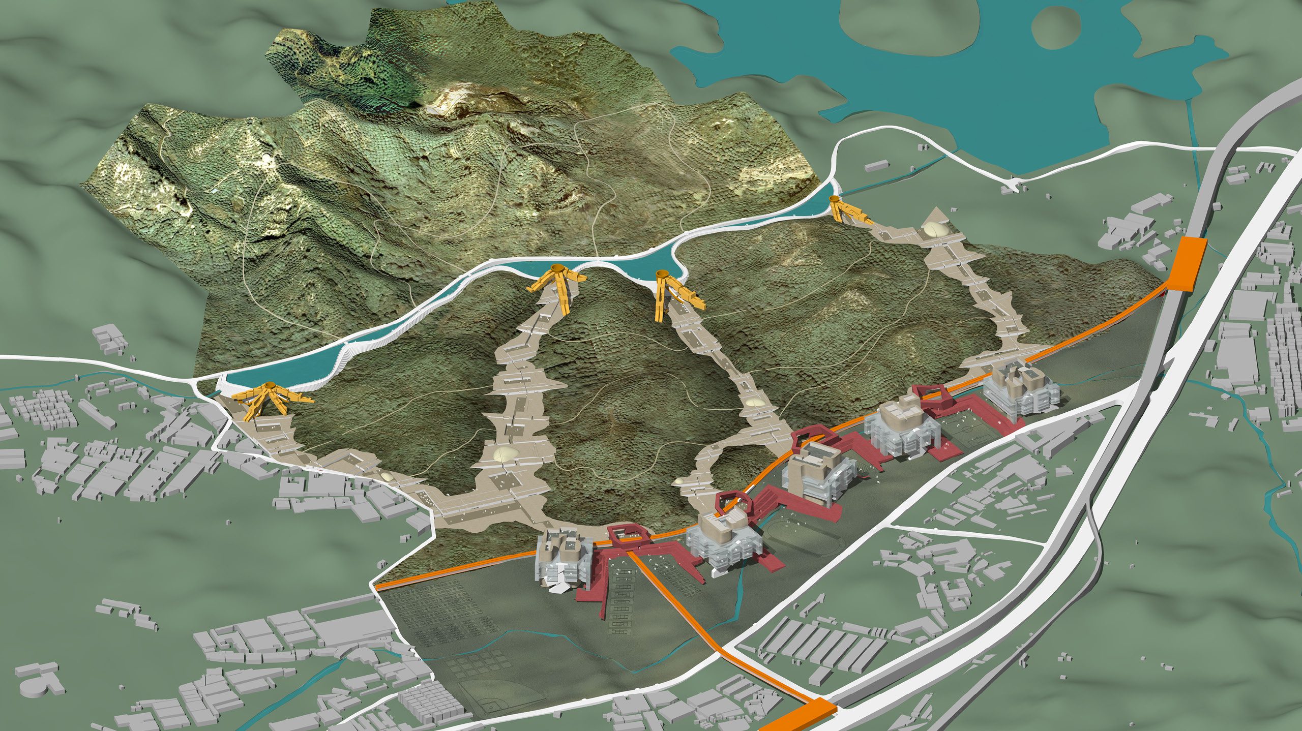
The conceptual master plan for the South University of Science and Technology will preserve the unique natural features on the site, and re-work the organizational particulars of the infrastructure to organize the project site. The governing planning strategy is to preserve the rolling, natural topography, particularly the hills and hill-tops, along with the courses of the natural water features on the site.
Buildings will not be positioned on the hillsides, but will be positioned to exploit long vistas, keeping the trees and water features, allowing immediate pedestrian access to foot paths on undeveloped portions of the site, and most importantly, proximity to the undisturbed natural landscape.
Rather than segregate the buildings, the master plan concept is to connect the building typologies as they extend across the site, using organizational strategies that allow a sequence of building and construction types that will conform to the different site topographies.
Different building strategies across the site will be a response to the intersection between a variety of building program requirement and a variety of landscape conditions.
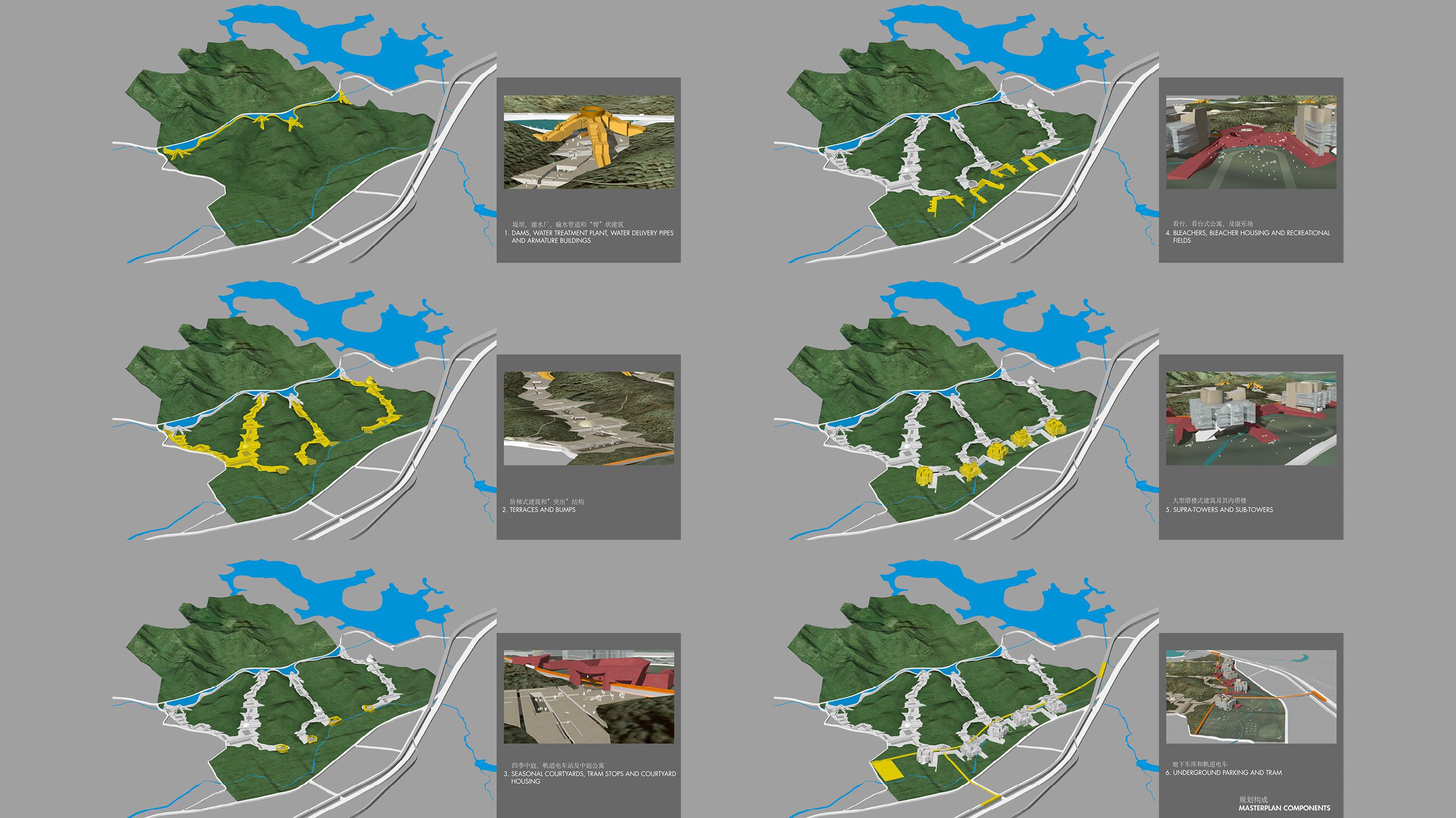
In order to preserve the hillsides, the plan identifies 5 natural “canyons” where a majority of existing building has taken place. All existing buildings will be removed from the canyon sites, as well as from the North Park. Development will also be cleared entirely in the rest of the site in order to completely re-organize the building design and construction premises for the site.
The road that penetrates the south west corner or the site will be re-located to the western perimeter. The road that defines the southern edge of the property will remain. Automobile access and parking on the site will be organized to take advantage of these two roads.
The two proposed 5th Line train stations, south of the project site, are essential to public access to the site area, and will be organizationally linked to the project interior.
The master plan for the South University of Science and Technology is divided into three governing zones – the northern, the southern, and a mediating zone in between.
Just south of the barrier road, on the site of the existing river, a new reservoir will be created, fed by the Chang Xi aqueduct. The new “lake” will introduce a prominent water feature to the north zone of the site, with sailing and boating as a recreational option for students and faculty. The shape of the lake grows wider then narrower then wider as a response to the site topography. The south wall of a new dam circumscribes the south edge of the lake, and defines the built edge of the new campus. Within the north dam wall is a new, east-west pedestrian walk and bicycle path along the top of the dam over-looking the campus to the south, and the lake and park to the north.
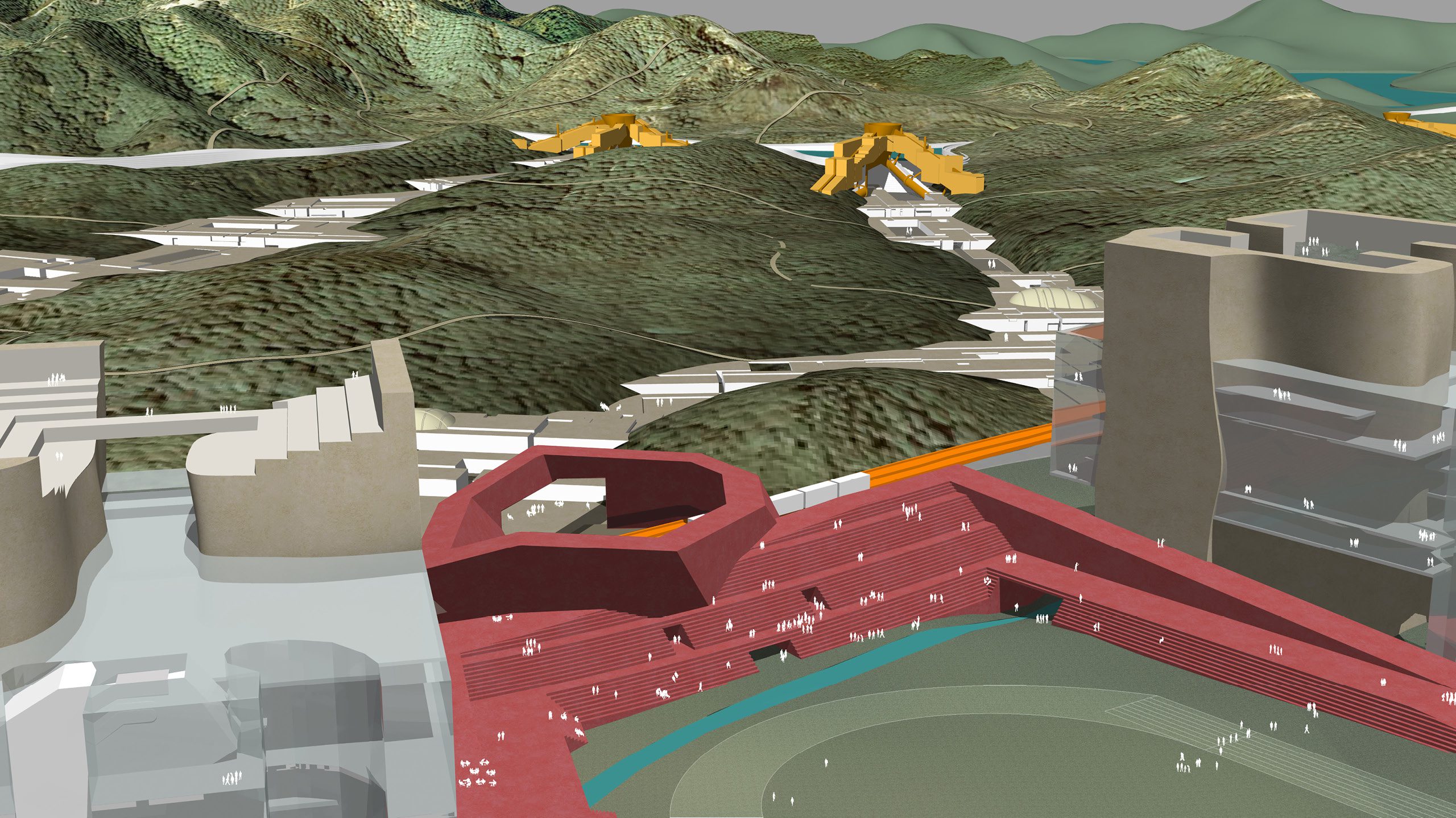
The conceptual organization of the south zone of the new campus – the level portion of the site — relies on the two proposed 5th line train stops, just south of the south property line. To facilitate campus access, a new pedestrian, bicycle, and campus tram route will be built, connecting the southern 5th line stop east-west through the campus to the south-eastern stop. New comers to the campus will leave the train and walk, take the tram, or ride bicycles to one of the four new “seasonal” courtyards that surround each tram stop.
Each court has both operational and symbolic meanings. The shape of each court represents a pattern of sunlight during a particular season of the year. The walls of the courts incline to maximize the sunlight in the summer court during the summer solstice, in the fall court during the fall equinox, in the winter court during the winter solstice, and in the spring court during the spring equinox. The courts are named by season consistent with the fundamental planning interest in describing a precise relationship between the natural environment and the systems of construction which depend on topographic and sunlight conditions.
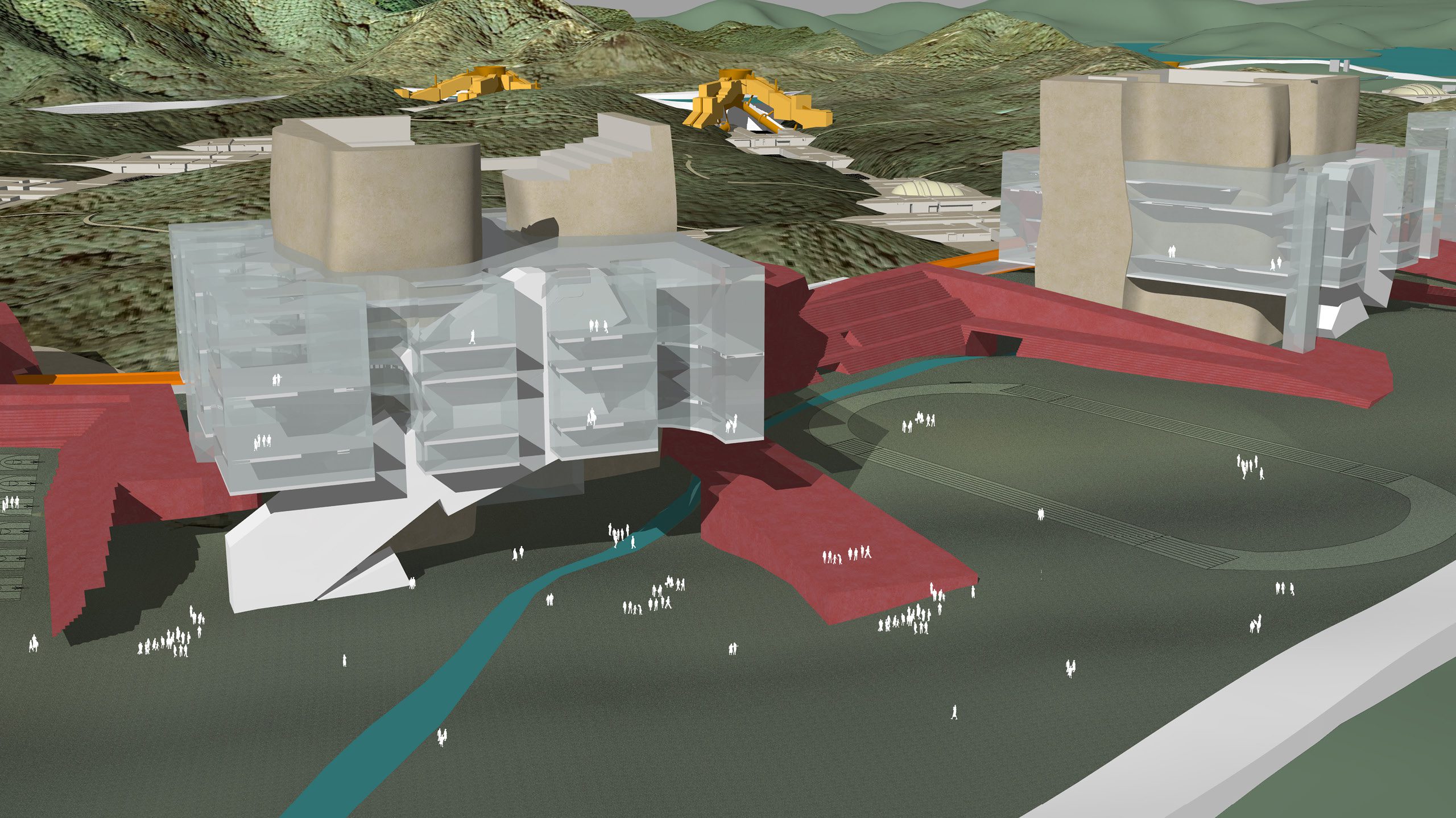
The four courtyards are not only the stopping points of the tram lines and the primary points of arrival and orientation on the campus site, they also contain student housing, encircling the courts. Connected to the four courtyards, directly to the south are the four bleacher buildings that contain student housing and additional student support services – administration, dining, and indoor recreational facilities, – surrounding the outdoor fields and recreational facilities.
Adjoining the bleacher buildings and fields are the five supratower buildings, each 90 m x 90m squares in plan. These supra-structures are composite towers, atypically large for single buildings, which permit the combination of a number of program elements that are typically organized separately in more conventionally smaller dimensions. The conception of five large structures, each representing one of the five campus colleges, consolidates program uses in a few large buildings rather than a larger number of smaller structures, thereby freeing a larger portion of the site to remain as natural landscape, or for recreational fields. The towers contain two or three “sub-tower” structures within the larger supra-tower plan. These two or three large vertical solids in each tower are surrounded by large, open floors with glazed perimeters. The sub-towers will contain media centers, conference centers, laboratories, libraries, and on the tops of each set of sub-towers, a restaurant and garden. The large, open floors are sufficiently flexible to accommodate administrative offices, research and development services, student services, or classrooms as the program varies from college to college.
The Da Sha River will continue its east-west course across the southern zone of the site, passing around, and in some cases through or under the four tram-stop courtyards, the housing-bleacher buildings, the supra-towers, and the playing fields.
The mediating plan zone connects the courtyards on the south with the new dam wall on the north. Five valleys or canyons, areas that currently hold a significant number of existing buildings, are identified as areas for mediating zone development. Each of five terrace/stepping building sequences, conforming to each of the five valleys, represents one of the five required campus colleges.
The terraced buildings follow the site areas between the hills, and therefore protect the hillsides and hill-tops from development.
The unbuilt portions of the site adjoin the terrace decks, and it is possible to move from one sequence of terraces in one college to the adjoining sequence of terraces, either east or west, by following pedestrian foot paths that conform to the hillside contours, over the natural landscape to the next terraced building site.
The terraces represent a sequence of stairs that extend from the lowest elevations at the south end of the site to the highest elevations at the dam. Each terrace is itself a one story building, with glazing facing the south elevation, and the roof deck of the adjacent step to the south. The courtyards recessed within each step are protected areas for outdoor gatherings, surrounded by classrooms, lecture halls, laboratories, or various other student services and amenities, that all face out to the courts. For each of the five terrace sequences an indoor sports activity building — the bumps — is provided, protruding from the terrace step. The pedestrian and bicycle routes in the mediating zone run north from the tram courts up through each of the five terraced buildings to the dam.
At the top step, the northern-most terrace in the sequence, is the new armature building. Four of these multi-armed, faculty housing buildings, step down the face of the dam, straddling the last several terraces, and land either on the terraces or in the natural landscape adjacent. Water from the new dam moves from filtering tanks on the dam wall through steel pipes, which also serve as structural supports for the housing arms stepping down the dam wall. The pipes are themselves stepped, so that from the top terraces pedestrians circulate up the pipe steps to the pedestrian walk along the top of the dam.